Sinhgad Fort
The DXG group and I took a trip to Sinhgad today as a team-building exercise. It was very fun and educational, and I got to see much more of the countryside around Pune. I rode in the car (along with Swapna and one other alternating DXG engineer depending on who wanted to ride a bike at the time). The rest of the DXG group rode bikes - here is the DXG-Pune Biker Gang riding off into the hills:

We stopped for breakfast at a little roadside restaurant. They served rice and chai.
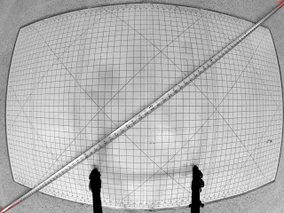
 Finally, after roughly 30km of driving over rough, twisty roads, we arrived. All the subsequent pictures are labeled relative to the numbers on this map (you can find an aerial photograph on Google Maps - note that it is turned 90 degrees - on this map, west is up).

Point #1 - the entrance - here is the group, trekking through the gate:

We climbed up and turned around for a quick photo:
...and then headed across the plateau. Just across the narrow point from the entrance gate (approximately at point #2 - the arrow shows the direction I was looking) we got this great view of another of the gates - down below, you can see close-up photos of it. I'm calling this the "west gate" - it has another name, but my Devanagari / Marathi skills are not up to deciphering it yet.

Moving back to the interior of the plateau (near Point 3 on the map) are the former stables. The natural water table that feeds the spring on the plateau has also put water in the stable:

Speaking of springs, here is one of the residents of the fort going to fetch water, pretty much as it has been done for thousands of years:

Also near this point, this shrine is found. Note the swastika on it - you can find this ancient symbol on the majority of the shrines and many households in the area:

Getting back to water, the fort is well-supplied by a natural spring. Probably something about the geography of the plateau causes water to soak into the ground and then bubble out at this comparatively low point.

Continuing our hike, we got to point #4 on the map. This is anther of the gates, and still very impressive:

Up high on the tower to the right in that picture there is an elephant gargoyle (not sure if it is "just" an elephant or if it is intended to represent Ganesha):

We posed again for a picture on top of that left tower:

We then continued to point #5 on the map, where I snapped this photo of the wall snaking along the western edge of the plateau (again, the arrow on the map shows the direction I was looking):

We continued along that edge of the fort, where I took this picture near point #6:

Here's the team coming up the hill toward point #7:

Point #7 on the map is the farthest point from the parking lot. We stopped for another group photo before moving along:

Walking across the middle of the plateau, we came to this monument to Tanaji Malusare, the Marathi hero who conquered the fort (occupied by Moghuls at the time) at the cost of his own life:

Finally, on the way down to the parking lot, the group stopped for a glass of lemonade hand-squeezed right in front of us (I'm getting on a plane tomorrow so I declined - did not want to risk anything just before a 14-hour ride with only an airplane lavatory for solace):

All-in-all, a thoroughly enjoyable experience. Thanks to the DXG-Pune team for a great team-building exercise!

We stopped for breakfast at a little roadside restaurant. They served rice and chai.
 Finally, after roughly 30km of driving over rough, twisty roads, we arrived. All the subsequent pictures are labeled relative to the numbers on this map (you can find an aerial photograph on Google Maps - note that it is turned 90 degrees - on this map, west is up).
Point #1 - the entrance - here is the group, trekking through the gate:

We climbed up and turned around for a quick photo:
...and then headed across the plateau. Just across the narrow point from the entrance gate (approximately at point #2 - the arrow shows the direction I was looking) we got this great view of another of the gates - down below, you can see close-up photos of it. I'm calling this the "west gate" - it has another name, but my Devanagari / Marathi skills are not up to deciphering it yet.

Moving back to the interior of the plateau (near Point 3 on the map) are the former stables. The natural water table that feeds the spring on the plateau has also put water in the stable:

Speaking of springs, here is one of the residents of the fort going to fetch water, pretty much as it has been done for thousands of years:

Also near this point, this shrine is found. Note the swastika on it - you can find this ancient symbol on the majority of the shrines and many households in the area:

Getting back to water, the fort is well-supplied by a natural spring. Probably something about the geography of the plateau causes water to soak into the ground and then bubble out at this comparatively low point.

Continuing our hike, we got to point #4 on the map. This is anther of the gates, and still very impressive:

Up high on the tower to the right in that picture there is an elephant gargoyle (not sure if it is "just" an elephant or if it is intended to represent Ganesha):

We posed again for a picture on top of that left tower:

We then continued to point #5 on the map, where I snapped this photo of the wall snaking along the western edge of the plateau (again, the arrow on the map shows the direction I was looking):

We continued along that edge of the fort, where I took this picture near point #6:

Here's the team coming up the hill toward point #7:

Point #7 on the map is the farthest point from the parking lot. We stopped for another group photo before moving along:

Walking across the middle of the plateau, we came to this monument to Tanaji Malusare, the Marathi hero who conquered the fort (occupied by Moghuls at the time) at the cost of his own life:

Finally, on the way down to the parking lot, the group stopped for a glass of lemonade hand-squeezed right in front of us (I'm getting on a plane tomorrow so I declined - did not want to risk anything just before a 14-hour ride with only an airplane lavatory for solace):

All-in-all, a thoroughly enjoyable experience. Thanks to the DXG-Pune team for a great team-building exercise!


Comments
We missed you while we gorged ourselves with turkey today, so I think we should have another Thanskgiving next week.