Our first stop on Tuesday the 26th was a beach on the north shore of Santa Cruz island. We started on this beach, and then walked to Las Bachas. On the way, we saw much wildlife, including our friend El Canario María:
Yellow Warbler
We saw our first of many Lava Lizards:
Lava Lizard
Lava Lizard
Lava Lizard
Lava Lizard
And the ever-present Sally Lightfoot Crab and Frigatebird:
Sally Lightfoot Crab
Frigatebird
Las Bachas beach is named after "las bachas" - remains of barges abandoned by the US at the end of WWII that floated to the beach and have remained there rusting ever since:
Group at Las Bachas
Las Bachas
On the way back, we stopped by a salt lake where flamingos can be found (we did not find one). However, we did find other things, including a Marine Iguana bathing:
Marine Iguana
Various shorebirds were in and around the lake:
Black-necked Stilts
Black-necked Stilt
Sanderling and Plover
Sanderling taking wing
Plover and Sanderling
Whimbrel
We returned to the original beach, where many of our party went snorkeling. Jill and I, however, stayed on shore to watch birds and other wildlife. We were rewarded! Many Sally Lightfoot crabs:
Sally Lightfoot Crab
Sally Lightfoot Crab
A nice little Lava Heron (I think):
Lava Heron
Lava Heron
Lava Heron
Several Brown Pelicans floating through:
Brown Pelican
Brown Pelican
Brown Pelican
Brown Pelican
A Great Blue Heron coming in for the evening:
Great Blue Heron
Great Blue Heron
More Yellow Warblers and finches:
Yellow Warbler
Darwin Finch
Our first Galápagos Flycatcher (we would see more on a subsequent island):
Galápagos Flycatcher
Another Whimbrel:
Whimbrel
More Galápagos Plovers:
Galápagos Plover
Galápagos Plover
A Wandering Tattler:
Wandering Tattler
Wandering Tattler
Marine Iguanas:
Marine Iguana
And, of course, the elusive Bare-footed Jilly Bird:
Jill
Once everyone else was done snorkeling, we returned to the ship:
MV Origin
We got underway while we lunched:
Before we disembarked, I watched our hard-working crew unload a Panga. Much activity like this went on behind the scenes and we were not generally aware of it as passengers. This is sped up 6x.
Our destination for the afternoon was Cerro Dragón, "Dragon Hill", named because it looks somewhat like the head of a Land Iguana from some angles. Here it is from the beach:
Cerro Dragon
On the beach and the early part of our hike we found more of our friends the Marine Iguanas:
Marine Iguana
Marine Iguana
Marine Iguana
There were Boobys diving for food:
I found bumblebees in the foliage:
Bumblebee
And we found more Sanderlings:
Sanderling
As well as our sentinel, the Mockingbird:
Galápagos Mockingbird
It was a warm day, and the hike was through desert terrain. Always bring water and wear sun protection!
Hiking at Cerro Dragón
We were on the hunt for Land Iguanas. We found evidence of their existence, including tracks and a bone:
Land Iguana tracks (with people tracks)
Iguana Vertebra
And then we found what we were looking for - a nice big Land Iguana. Very different from the Iguanas seen on the mainland:
Land Iguana
Land Iguana
Land Iguana
Land Iguana
Land Iguana
Land Iguana
We saw five or six land iguanas that day.
We made it to the top of the hill and I stopped to take a panorama:
On 1 April 2026, the Artemis II mission launched for a crewed trip around the Moon. I had heard that, in the Apollo missions, the spaceships were viewed and/or imaged from several ground-based telescopes, and I wanted to try it myself. The first task was to figure out where, exactly, the capsule would be. After figuring out that the "Integrity" would rise from my location around midnight, and after verifying that I might have some clear weather, I used the JPL Horizons database to generate an ephemeris of the right ascension/declination coordinates as seen from my location: I saved it as a CSV and imported it into a spreadsheet, where I used a table of predicted brightness values based on distance to figure out if it would *really* be visible: I also imported these coordinates into Stellarium so I could visualize their actual location in the sky at the various times. I did this by creating a Javascript script that I then pasted into the Stellarium script editor: The m...
On December 18, 2014, I received a letter from Rocky Scott, the Director of Corporate Relations with Woodward, Inc. The letter was remarkable for its bullying and intimidating tone. It also repeated several false statements, in an apparent attempt to extract more taxpayer money from the citizens. In response, here are the facts: Homestead Natural Area was not a gift from Woodward. It was part of a $23.5 million taxpayer-financed package, which was adopted by Council on March 26, 2013. The agreement says the property was “conveyed”, not donated, which just means Woodward transferred ownership to the City as part of the deal. The City of Fort Collins is not required to ask the voters for millions of additional dollars to fund the Lincoln Avenue project next to Woodward. It has always been up to Council whether or not to refer this question to the voters. And, if Council should ask, you are free to vote “no” on the question. It is impor...
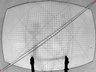
I got two GoPro Hero3 Black cameras and am planning a panoramic project with them. However, to do the project correctly and accurately, I need a good read on their field-of-view. So, I set up a tripod and a grid and a tape measure, and took a few photos. Here they are, desaturated and contrast-enhanced, with central red dots and some annotations. First, measuring the diagonal FOV: Next, the horizontal FOV: Finally, the vertical FOV: The front of the camera lens was almost exactly 17 inches from the grid. The camera body started about 17.25 inches from the grid. Assuming the sensor is embedded some distance into the body, I used an estimated field-to-sensor distance of 17.5 inches. This yields the following field-of-view, in degrees: Diagonal: 146 Horizontal: 121 Vertical: 93 Doing a little interval math on the field-to-sensor distance shows these angles are accurate to about plus or minus 1.5 degrees. Int...


Comments